Africa's highest peak. Five proven routes. Experienced crews and a safety record built over nearly three decades.
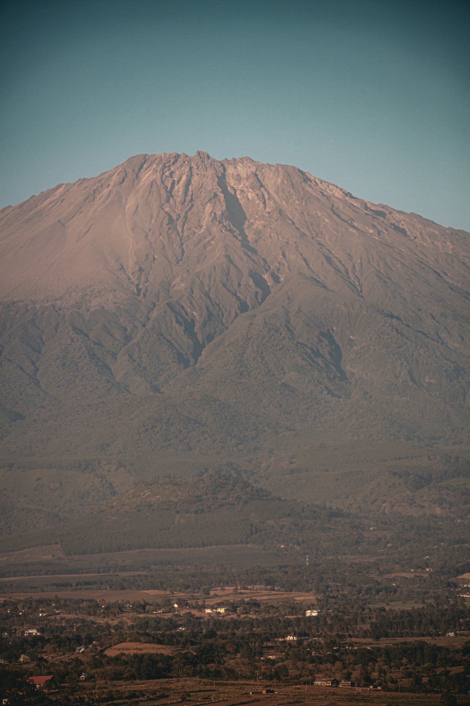
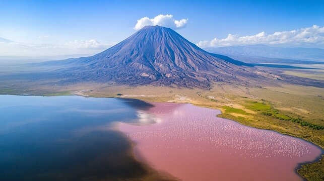
Mount Kilimanjaro stands at 5,895 metres (19,341 feet) above sea level — the highest point on the African continent and the tallest free-standing mountain anywhere on earth. Situated just three degrees south of the Equator in northern Tanzania, its snow-capped summit is visible from well over a hundred miles away on a clear day, rising with astonishing abruptness from the surrounding plains.
Kilimanjaro is not a single peak but three distinct volcanic cones. Shira, the oldest, is now extinct and has collapsed into a broad caldera plateau at around 3,800 metres. Mawenzi, also extinct, rises to 5,149 metres (16,890 feet) in a dramatic cluster of jagged pinnacles and sheer rock faces that make it one of the most technically demanding summits in Africa. Kibo, the youngest and still classified as active, forms the familiar dome-shaped summit reaching 5,895 metres. Within its crater, fumaroles still release sulphurous gases — a quiet reminder that this giant is merely dormant, not dead.
The mountain's origins lie in the immense geological forces of the Great Rift Valley. Between two and three million years ago, deep fractures in the earth's crust allowed molten rock to break through the surface, building the three volcanoes that today form the Kilimanjaro massif. The result is a mountain of extraordinary geological variety: ancient lava flows, glacial moraines, volcanic ash fields, and the remnants of ice caps that have covered the summit for over ten thousand years.
No technical mountaineering experience is required to reach the summit, though the climb is physically demanding and altitude must be treated with respect. Our experienced guides follow the traditional "Pole Pole" — slowly, slowly — approach, moving at a pace that maximises acclimatisation and gives you the best possible chance of standing on Uhuru Peak.
Book Your ClimbKilimanjaro is unique among the world's great mountains in the sheer range of ecosystems you pass through on the way to the summit. From cultivated farmland to equatorial rainforest, from giant heather moorland to an alpine desert that resembles a moonscape, and finally to an arctic summit zone complete with glaciers and sulphurous volcanic vents — each day of climbing brings an entirely different landscape.
| Zone | Altitude | What You Will See |
|---|---|---|
| Lower Slopes | 800–1,800m (2,600–5,900 ft) | Cultivated farmland, Chagga settlements, coffee and banana plantations. The mountain's human story begins here — the Chagga people have farmed these fertile volcanic slopes for centuries. |
| Montane Forest | 1,800–2,800m (5,900–9,187 ft) | Dense, dripping rainforest that receives up to 96% of Kilimanjaro's total rainfall. This is the mountain's most fertile and biodiverse zone — home to black-and-white colobus monkeys, blue monkeys, leopards (rarely seen), elephants, and an extraordinary variety of birdlife. The canopy filters the light into a cathedral-like green glow. |
| Heath & Moorland | 2,800–4,000m (9,187–13,120 ft) | The forest thins into giant heathers that can reach 10 metres (30 feet) in height — an eerie, otherworldly landscape. Higher up, the vegetation becomes increasingly sparse, with giant lobelia and groundsel plants standing like sentinels in the mist. On clear days, the views across the Shira Plateau and down to the plains below are immense. |
| Highland Desert | 4,000–5,000m (13,120–16,400 ft) | A barren, rocky landscape of volcanic scree and boulders with extreme temperature swings — daytime temperatures can exceed 40°C in direct sun while plummeting below freezing at night. Very little grows here. The air is noticeably thin, and the landscape has an austere, lunar beauty. |
| Arctic Summit | 5,000–5,895m (16,400+ ft) | Ice, rock, and sky. The summit zone is a true arctic environment despite sitting almost on the Equator. Within Kibo's crater, yellow sulphur deposits and volcanic steam vents mark the boundary between geology and atmosphere. The glaciers, though retreating, remain magnificent — sheer walls of ancient ice glinting in the equatorial sun. |
Each route has its own character, difficulty, and rewards. We operate all five and will help you choose the right one based on your fitness, schedule, and the kind of experience you are looking for. Below is an overview of each, followed by full day-by-day itineraries.
The most popular route on the mountain, known as the "Whiskey Route" for its steeper, more demanding terrain compared to the gentler Marangu. Superb scenic variety — rainforest, moorland, the Shira Plateau, the Great Barranco Wall, and an unforgettable pre-dawn summit push.
Often described as the most beautiful way up the mountain — unspoilt, remote, and less-used. The longer approach via the western Shira Ridge gives the best acclimatisation of any route, which is why Lemosho consistently delivers the highest summit success rates.
The "Coca-Cola Route" — the oldest and most established path to the summit. The only route offering hut accommodation rather than tents, and the only route that ascends and descends the same way. Straightforward gradients suit those who prefer a less technical climb.
The only route approaching from the north, near the Kenyan border. Rongai is the driest route on the mountain, making it the best choice during the wetter months. Quiet trails, gentle gradients, and a true wilderness feel through pine forest and open moorland.
Often considered the hardest but most spectacular and direct way to the summit. The route follows a narrow, dramatic ridge with sheer drops and unobstructed views of the Breach Wall. Recommended only for fit, experienced high-altitude trekkers.
Machame is the most popular route on Kilimanjaro, and for good reason. It offers tremendous scenic variety, moving through every vegetation zone on the mountain. The route follows the "climb high, sleep low" principle — on Day 3 you ascend to the Lava Tower at 4,600 metres before descending to sleep at Barranco Camp, which significantly aids acclimatisation. The famous Barranco Wall scramble on Day 4 is one of the most memorable moments of any Kilimanjaro climb.
Walking time: 5–7 hours. You begin at Machame Gate on the southern side of the mountain, where porters organise loads and park fees are checked. The trail enters dense montane rainforest almost immediately — a lush, dripping world of moss-covered trees, ferns, and filtered green light. The path is well-defined but can be muddy, particularly after rain. You gain over 1,200 metres of altitude through the forest before emerging at Machame Camp on the edge of the heath zone. First views of Kibo's summit dome appear through breaks in the canopy.
Walking time: 4–6 hours. The trail climbs steeply out of the forest into open heath and moorland. The vegetation transforms dramatically — giant heather gives way to tussock grass, and you begin to see the extraordinary giant lobelia and groundsel plants that are unique to East African high-altitude environments. The landscape opens out as you reach the broad Shira Plateau, one of the most atmospheric locations on the mountain. Camp is set in a wide valley with panoramic views across the plateau and, on clear evenings, spectacular sunsets over the western escarpment.
Walking time: 6–7 hours. This is the key acclimatisation day. You cross the Shira Plateau heading east toward Kibo, ascending steadily through increasingly barren landscape to the Lava Tower — a massive volcanic rock formation at 4,600 metres. Many climbers feel the altitude here for the first time: headaches, breathlessness, and fatigue are common and entirely normal. After lunch at the Lava Tower, you descend over 600 metres to Barranco Camp, tucked beneath the imposing Barranco Wall. The principle of "climb high, sleep low" is at work — your body has been exposed to higher altitude and will acclimatise more effectively overnight at the lower camp.
Walking time: 3–4 hours. The day begins with the celebrated Barranco Wall — a steep, rocky scramble that looks far more intimidating than it is. This is hands-on climbing rather than walking, picking your way up rock ledges with the valley dropping away beneath you. There is no technical equipment needed, but a reasonable head for heights helps. The sense of achievement on reaching the top is considerable. From there, the trail undulates through alpine desert terrain to Karanga Camp, set in a valley with views across to the summit glaciers. A shorter day allows for rest and recovery.
Walking time: 3–4 hours. A steady ascent through rocky, barren terrain to Barafu — your summit base camp. The name means "ice" in Swahili, and nights here are bitterly cold. You arrive by early afternoon, eat, and attempt to sleep. Your guides will wake you around midnight for the summit push. The atmosphere at Barafu is electric with anticipation — headlamps dot the mountainside as climbers from multiple routes converge for the final ascent.
Walking time: 7–8 hours ascent, 4–6 hours descent. The pre-dawn departure is the hardest part of the entire climb. You ascend steep scree and switchbacks by headlamp in bitter cold, each step deliberate and effortful in the thin air. The pace is painfully slow — and deliberately so. After five to seven hours, you reach Stella Point (5,685m) on the crater rim, where the sky begins to lighten. From Stella Point, a further 45 minutes along the crater rim brings you to Uhuru Peak — the Roof of Africa at 5,895 metres. On a clear morning, the sunrise illuminates the glaciers in shades of pink and gold, and the shadow of the mountain stretches across the plains far below. After photographs and celebration, you descend — first back to Barafu for a rest and hot drink, then continuing down to Mweka Camp at 3,110 metres, where the forest begins again and the air feels thick and warm and wonderfully rich.
Walking time: 3–4 hours. A gentle descent through rainforest to Mweka Gate, where your summit certificate is presented. The forest is alive with birdsong and the smell of damp earth — after days in the barren alpine desert, it feels almost tropical. Your vehicle waits to transfer you back to Arusha. You have climbed Kilimanjaro.
Lemosho is widely regarded as the finest route on Kilimanjaro — an unspoilt, remote, and strikingly beautiful way up to the Shira Plateau from the west. Because of the longer approach, the route allows excellent acclimatisation, and it consistently achieves the highest summit success rate of any route on the mountain. The first two days are spent in pristine forest with very few other climbers. From Day 4 onwards, the route joins the Machame trail and shares the same dramatic Barranco Wall scramble and summit approach.
Walking time: 3–4 hours. After registering at Londorossi Gate on the western flank of the mountain, you drive a short distance to the trailhead and enter pristine montane rainforest. The path is well-shaded and relatively gentle, winding through a dense canopy of camphor and fig trees. "Mti Mkubwa" means "Big Tree" in Swahili, and the camp sits in a clearing surrounded by towering forest giants. You are likely to have the forest almost entirely to yourself — a marked contrast to the busier southern routes.
Walking time: 6–7 hours. A longer day that takes you up through the Shira Ridge and out of the forest into open heath and moorland. The landscape change is dramatic: the dense canopy gives way to giant heathers, wildflowers, and increasingly expansive views. You cross several small streams and begin to feel the altitude as you gain over 750 metres. Shira 1 Camp sits on the western edge of the vast Shira Plateau — a high-altitude grassland that was once the floor of an ancient volcanic caldera.
Walking time: 3–4 hours. A deliberately shorter day to aid acclimatisation. You cross the Shira Plateau, a surreal, treeless landscape scattered with volcanic boulders and dotted with giant lobelia. Optional acclimatisation walks in the afternoon take you higher before returning to camp. The evening views from Shira 2 are magnificent — the sun sets behind Mt Meru to the east, and Kibo's summit dome glows in the last light.
Walking time: 5–6 hours. The route heads east toward Kibo, ascending through alpine desert to the Lava Tower at 4,600 metres. This is the crucial acclimatisation day — you climb high and sleep low. After lunch at the Lava Tower, you descend steeply through a landscape of giant groundsels to Barranco Camp, nestled beneath the imposing Barranco Wall. The afternoon clouds often roll in below you, and the feeling of being above the world is extraordinary.
Walking time: 3–4 hours. The day begins with the Great Barranco Wall scramble — a thrilling hands-on ascent up rock ledges, which is far less daunting than it appears from below. From the top, the trail traverses alpine desert terrain to Karanga Valley camp. A shorter day gives time for rest and recuperation before the push to high camp.
Walking time: 3 hours to Barafu, then 6–7 hours summit ascent. You reach Barafu high camp by midday, rest, eat, and attempt to sleep. Around midnight, the summit push begins. The ascent follows steep scree and switchbacks by headlamp to Stella Point (5,685m) on the crater rim, then 45 minutes along the rim to Uhuru Peak at 5,895 metres. The sunrise from the crater rim is one of the most remarkable sights in all of Africa.
Walking time: 7–8 hours total. After summiting, you descend from Uhuru Peak to Barafu for a rest, then continue down through the moorland and forest to Mweka Gate. The descent is long but joyful — the air thickens, the forest returns, and the birdsong after days of silence is almost overwhelming. Certificate presentation at the gate, then transfer to Arusha.
Marangu is the oldest and most established route on Kilimanjaro, and the only one offering sleeping huts rather than tents. The huts are basic but solid — bunk beds with mattresses and communal dining areas. The route follows the same path up and down, which means less variety of scenery than the circuit routes, but the gradients are generally gentler and the trail is well-maintained throughout. We strongly recommend the 6-day option with an extra acclimatisation day at Horombo Hut, which significantly improves your chances of reaching the summit.
Walking time: 3–4 hours. A gentle introduction through beautiful montane rainforest on a wide, well-maintained path. The forest is particularly rich on this eastern side of the mountain — look for blue monkeys, colobus monkeys, and a profusion of epiphytic orchids and ferns. Mandara Hut is a cluster of wooden A-frame huts in a forest clearing, with a short optional walk to Maundi Crater for your first views across to Mawenzi's jagged pinnacles.
Walking time: 5–6 hours. The trail leaves the forest and enters open moorland. The landscape transformation is striking — rolling hills of tussock grass dotted with giant lobelia and groundsel. Both Kibo and Mawenzi are visible ahead on clear days, and the sense of space after the enclosed forest is remarkable. Horombo Hut is the largest camp on the mountain, with capacity for over 100 climbers. It sits in a dramatic saddle between Kibo and Mawenzi.
A rest day that is strongly recommended and makes a significant difference to summit success rates. An optional walk to the Zebra Rocks — a striking formation of dark and light volcanic stripes at around 4,000 metres — provides gentle altitude exposure before returning to the comfort of Horombo for the afternoon. This is a day for reading, resting, drinking plenty of water, and letting your body adjust.
Walking time: 5–6 hours. The trail crosses "The Saddle" — a vast, flat expanse of alpine desert stretching nearly five kilometres between Kibo and Mawenzi. It is one of the most desolate and beautiful landscapes on the mountain, a semi-desert of volcanic gravel and scattered boulders under an immense sky. Kibo Hut sits at the base of the summit cone — a stone building at 4,730 metres where you eat an early supper and attempt to rest before the midnight wake-up call.
Walking time: 6–8 hours ascent, 4–6 hours descent. The summit push begins around midnight. The initial ascent crosses steep scree — loose volcanic gravel that is easier to climb when frozen in the pre-dawn cold. You follow switchbacks by headlamp to Gillman's Point (5,681m) on the crater rim, where you receive a certificate even if you go no further. From Gillman's, the trail follows the crater rim for approximately one hour to Uhuru Peak at 5,895 metres. The descent retraces your steps: back to Kibo Hut for a rest, then continuing all the way down to Horombo Hut. It is a very long day, but the mountain is behind you.
Walking time: 5–6 hours. The final descent passes through moorland and back into the rainforest. The path is the same one you walked up, but you will see it with entirely different eyes — the forest feels impossibly lush and green after days in the high desert. Certificate presentation at Marangu Gate, followed by transfer back to Arusha.
Rongai is the only route that approaches Kilimanjaro from the north, near the Kenyan border. It is the driest route on the mountain, sitting in the rain shadow of the summit dome, which makes it the best choice for climbers travelling during the wetter months of April, May, and November. The trail is quieter and more remote than the southern routes, with a genuine wilderness character. The recommended Mawenzi Tarn variation adds an extra day and takes you to one of the most spectacular campsites on the mountain — a glacial lake beneath Mawenzi's sheer rock towers.
Walking time: 2.5–3 hours. The day begins with a two-hour drive from Marangu through the small town of Loitokitok to Rongai Gate on the north-eastern flank of the mountain. The trailhead is close to the Kenyan border, and the landscape here is noticeably drier than the southern slopes. The path climbs gently through cultivated fields before entering pine and cypress forest. Simba Camp ("Lion Camp") sits in a clearing with views northward toward Kenya. You are likely to be one of very few groups on this part of the mountain.
Walking time: 3–4 hours. A gentle ascent through thinning bush and into a zone of giant heathers. The trail is well-graded and the walking pleasantly unhurried. You may see signs of buffalo and elephant at the forest edge. Second Cave camp is set in open moorland with increasingly expansive views of Kibo's northern flanks and the first clear sight of the Mawenzi massif to the east.
Walking time: 3–4 hours. A gentle traverse through open moorland with steadily improving views. The pace is deliberately slow to aid acclimatisation. The trail passes through a landscape of scattered boulders and tussock grass with the dramatic towers of Mawenzi growing ever closer. Kikelewa Caves camp sits beneath a rocky overhang — a sheltered spot with a wild, remote atmosphere.
Walking time: 3–3.5 hours. The trail climbs more steeply through moorland and then across volcanic scree to Mawenzi Tarn — a small glacial lake set in a dramatic amphitheatre directly beneath Mawenzi's jagged pinnacles. The setting is extraordinary: sheer rock walls rise hundreds of metres above the dark, still water. This is one of the finest campsites on any mountain in Africa. An afternoon acclimatisation walk toward the Mawenzi peaks is highly recommended.
Walking time: 4.5–5 hours. You leave the dramatic scenery of Mawenzi behind and cross "The Saddle" — the vast, flat alpine desert that separates Mawenzi from Kibo. The walking is straightforward but the altitude makes every step an effort. Kibo Hut sits at the base of the summit cone. Eat, drink plenty of water, and attempt to sleep before the midnight start.
Walking time: 6–8 hours ascent, 5–6 hours descent. The summit push follows the same route as Marangu — up through frozen scree to Gillman's Point, then along the crater rim to Uhuru Peak. After summiting, you descend the Marangu route to Horombo Hut, giving you a different perspective of the mountain on the way down. The contrast between the barren northern approach and the lush southern descent is striking.
Walking time: 5–6 hours. A straightforward descent through moorland and rainforest to Marangu Gate. Certificate presentation and transfer back to Arusha. Having ascended from the dry north and descended through the lush south, you will have seen two entirely different faces of Kilimanjaro.
Umbwe is often considered the hardest but most spectacular and direct way up Kilimanjaro. The route follows a narrow, knife-edge ridge through dense forest before emerging onto the southern glaciers with dramatic views of the Breach Wall — the sheer, ice-hung face of Kibo. The altitude gain is rapid and the terrain is demanding throughout. This route is not recommended for first-time high-altitude trekkers, but for those with experience and fitness, it offers an intensity and solitude unmatched by any other route on the mountain. You will likely not see another group for the first two days.
Walking time: 5–6 hours. From Umbwe village on the southern slopes, the trail plunges straight into dense, dark rainforest. The path follows a narrow, spectacular ridge between two river valleys — at times the ridge is barely wider than the trail itself, with steep drops on both sides. The forest is dense and atmospheric, with enormous trees draped in old man's beard moss. Tree roots form natural steps on the steeper sections. You gain over 1,100 metres through the forest to a camp set in a small clearing on the ridge.
Walking time: 5–6 hours. The ridge continues upward, the forest thinning as you gain altitude. The views begin to open out spectacularly — the immense Breach Wall of Kibo appears ahead, a sheer face of rock and ice nearly a kilometre high. This is one of the most dramatic sights on the mountain. The trail emerges from the forest into the heath and moorland zone, crossing rocky terrain to Barranco Hut, set beneath the Barranco Wall with the Breach Wall looming above.
Walking time: 3–4 hours. The Great Barranco Wall scramble — the same exhilarating hands-on ascent faced by climbers on the Machame and Lemosho routes. From the top of the wall, the trail traverses to Karanga Valley camp. A shorter day allows your body to recover from the rapid altitude gain of the first two days.
Walking time: 3–4 hours. A steady climb through barren alpine desert to Barafu — the summit base camp shared with the Machame and Lemosho routes. The terrain is rocky and exposed, with views across to the glaciers. Arrive by early afternoon, eat, rest, and prepare for the midnight departure.
Walking time: 7–8 hours ascent. The pre-dawn summit push follows the same route as Machame — steep scree and switchbacks to Stella Point, then along the crater rim to Uhuru Peak. Depending on conditions and the time of year, there may be snow and ice on the upper sections. Your guides carry the necessary equipment. After reaching the summit, begin the long descent.
After summiting and returning to Barafu, you descend through alpine desert and moorland to Mweka Hut. The relief of descending into thicker air is palpable. A hot meal and a proper night's sleep in the forest await.
Walking time: 3–4 hours. A gentle forest descent to the gate. The rainforest is thick and alive with sound — a welcome contrast to the silence of the upper mountain. Certificate presentation at Mweka Gate, then transfer to Arusha.
Two more extraordinary peaks for those who want to explore further — or who wish to acclimatise before tackling Kilimanjaro itself.
Tanzania's second-highest peak at 4,566 metres, rising directly above Arusha. Mount Meru is a superb trek in its own right and an excellent acclimatisation climb before Kilimanjaro. The route passes through Arusha National Park, where you walk with an armed ranger past buffalo, giraffe, waterbuck, and troops of black-and-white colobus monkeys. The summit ridge is narrow and exposed, with views across to Kilimanjaro that, on a clear morning, are simply breathtaking. We recommend three days on the mountain, sleeping in well-maintained huts.
Enquire
The "Mountain of God" in the Maasai language. An active volcano at 2,962 metres in the heart of the Great Rift Valley, Ol'Doinyo Lengai is the only volcano on earth that erupts natrocarbonatite lava — a calcium-rich substance that flows cool and black before turning white in the sun. The climb is a demanding overnight ascent, starting at midnight and reaching the surreal, otherworldly summit crater at dawn. Best combined with a visit to Lake Natron and an extension to the Serengeti.
EnquireEvery climb includes a full support crew and all the logistics. You bring your personal clothing and daypack — we handle everything else.
Tipping is customary in Tanzania and greatly appreciated by the mountain crew, who work extraordinarily hard to get you safely to the summit and back. The following are recommended daily rates per group:
$20–$25 per day
$15–$20 per day
$12–$15 per day
$10–$12 per day
Tell us your preferred dates and route — we'll put together a detailed itinerary and quote within 24 hours. No obligation, no pressure. Just honest advice from people who have been guiding on this mountain for nearly thirty years.
Plan Your Climb